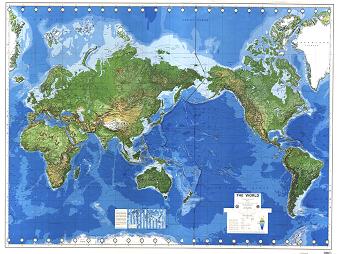
 Challenge: find a map of the Pacific Ocean that includes both Japan and California. Or that focuses on any of the island nations in between.
One of the casualties of mapping a three-dimensional planet on two-dimensional paper is the part of the world that is split between the edges of the paper. Usually, this is the Pacific. As Sarah Palin made famous in the 2008 presidential campaign, as an Alaskan, she can see Russia from her house. While I admit that for Palin, this is an exaggeration, but for the residents of St. Lawrence Island, this view is a reality. In fact, they are as likely (if not more) to speak Russian than English and have the capability of kayaking to Russia if so desired. But your average world map makes that distance look infinite.
What if we conventionally centered maps around the Pacific instead of Europe? A Google image search of “world map” took until the bottom of page 4 to find something that didn’t cut the Pacific in half. Even then, the map included extra bits; it wasn’t centered on the Pacific.

It would be a very different view. We tend to forget about what falls at the edges if it’s not visually connected and this can have very real consequences.
For instance, the nuclear fallout from Fukushima was often referred to as ‘lucky’ because the primary plume extended over the empty Pacific. As was pointed out in a New York Times OpEd, the Pacific isn’t empty space. There are nations there in addition to many important marine resources, not to mention charismatic fauna that capture worldwide imagination. The citizens of those nations never really get a fair cartographic representation. Some would go so far as to say that this is a form of elitism and ethnocentrism, placing the Europe in the center of the world as it stood in the minds of historic cartographers that first mapped the world. It might be time to revisit and re-center.


In Australia most world maps tend to be centered on Australia (e.g. http://shop.australiangeographic.com.au/World-Map-Poster-P1429.aspx ) but still are quite poor on Small Island Pacific States..
I prefer this map:
http://images.google.com/imgres?q=world+according+to+americans&num=10&hl=en&gbv=2&biw=1366&bih=667&tbm=isch&tbnid=XTKqvepv-6XnRM:&imgrefurl=http://www.ritholtz.com/blog/2009/11/the-world-according-to-americans/&docid=o1nvqy_trg3MEM&w=917&h=589&ei=1L2PTp77AsmvsQLe0IWmAQ&zoom=1